Satellite Images Discovered There Are More Coral Reef Areas Than We Thought
16th Feb 2024
Recent research led by the University of Queensland (UQ) has unveiled a broader extent of coral reef areas worldwide than previously documented. Scientists used satellite mapping to detect the coral reef areas and hope the data will aid in the conservation of these crucial ecosystems.
Satellite images might help save coral reef
Dr. Mitchell Lyons, from UQ’s School of the Environment, working in conjunction with the Allen Coral Atlas project, disclosed that scientists have now pinpointed 348,000 square kilometers of shallow coral reefs, extending up to depths of 20–30 meters. The findings have been published in the research paper featured in Cell Reports Sustainability.
“This revises our previous estimation of shallow reefs within the world’s oceans,” Dr. Lyons affirmed.
He further emphasized the significance of the high-resolution satellite mapping technology, stating, “Importantly, the high-resolution, up-to-date mapping satellite technology also allows us to see what these habitats are made from.”
Dr. Lyons elaborated, “We’ve found 80,000 square kilometers of reef have a hard bottom, where coral tends to grow, as opposed to soft bottom like sand, rubble or seagrass. This data will allow scientists, conservationists, and policymakers to better understand and manage reef systems.”
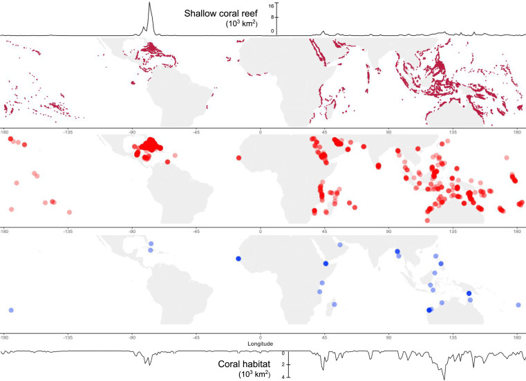
The research utilized over 1.5 million samples and analyzed 100 trillion pixels from the Sentinel-2 and Planet Dove CubeSat satellites to capture fine-scale details on a high-resolution global map.
“This is the first accurate depiction of the distribution and composition of the world’s coral reefs, with clear and consistent terminology,” Dr. Lyons stated. “It’s more than just a map—it’s a tool for positive change for reefs and coastal and marine environments at large.”
To protect the nature
Associate Professor Chris Roelfsema, also from UQ, highlighted the collaborative nature of the reef mapping project, involving over 480 contributors, and its immediate impact on coral reef conservation efforts globally.
“The maps and associated data are publicly accessible through the Allen Coral Atlas and Google Earth Engine, reaching a global audience,” Dr. Roelfsema noted.
He added, “The details provided by these maps empower scientists, policymakers, and local communities to make informed decisions for the preservation of our coral reefs.”
The Allen Coral Atlas initiative, spearheaded by the late Paul Allen’s Vulcan Inc. and managed by Arizona State University in collaboration with partners from Planet, the Coral Reef Alliance, and The University of Queensland, stands as a testament to collaborative efforts in advancing coral reef conservation on a global scale.


Thank you for your comment! It will be visible on the site after moderation.