Satellites Orbits: Types & Uses Explained
28th Mar 2022
The launch of the first artificial satellite took place back in 1957 and marked the beginning of the great space and satellites orbits era for mankind. Since then, space traffic has become commonplace. Today, there are thousands of satellites around Earth, and each, depending on its purpose and the territory served, has a residence permit in a certain orbit. This article will discuss the definition of an orbit, satellite orbit models and applications.
What is an orbit
The term “orbit” (from the Latin orbita “track, road, way”) was first used by the German mathematician, Johannes Kepler, in 1609. From the point of view of astronomy, this is a closed curved trajectory of a celestial body in the gravitational field of another body with a much larger mass. In our case of satellite orbits classification, this is the trajectory of the satellite in the gravitational field of the Earth – a kind of district road of the Earth.
There are many satellite orbits around Earth that can be used, but before we discuss the map of satellite orbits, let us define the basic principles and concepts, along with satellite orbital parameters.
How to launch a satellite into orbit and keep it there?
To deliver a satellite into orbit, you need a booster rocket. It takes the spacecraft to the calculated height and, with the help of an impulse, accelerates it to orbital speed (several kilometers per second). Further, the satellite moves by inertia equal to the force of attraction (gravity) of the Earth.
Keeping the balance between gravity and inertia depends on how long does a satellite stay in orbit. If the inertia is stronger than gravity, the satellite will leave the orbit and rush into outer space; if it is weaker, the satellite will fall down to the Earth and probably burn down on the way. The ground control centre ensures this does not happen, implementing satellite orbit control and, if necessary, satellite orbit correction based on precisely calculated parameters.
Satellite orbital parameters: basic definitions
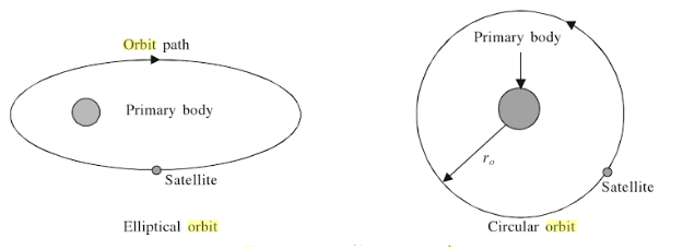
All satellites revolve around the Earth in a circular or elliptical orbit. In the first case of satellite orbits around Earth, the object is always at the same distance from the planet and rotates at the same speed; in the second case of satellite orbits around Earth, the distance changes at different times during one revolution, and the satellite orbital velocity increases when approaching the center of the Earth (geocenter) and decreases when moving away from it.
The distance from the Geocentre to the Earth’s surface is the radius of the Earth (3960 miles), and it is always taken into account when determining the satellite orbits’ attitude and satellite orbital velocity. Jumping ahead, let’s say that the altitude for most satellite orbits and missions varies from 160 km to 36,000+ km.
If the satellite rotates in the same direction as the Earth, its orbit is called direct; if it rotates in the opposite direction, retrograde is the term for satellite orbits classification. Also, satellite orbits can have different elevation angles above the horizon line and different inclination angles (relative to the equatorial axis and the north-south axis). The elevation angle also determines satellite reception signal and satellite orbital velocity. Five degrees is the minimum allowable angle for satisfactory reception for most satellites orbits and missions.
The tilt angle determines the satellite orbits types or how the orbit track will look. In other words, the projection of the movement of the sub-satellite point onto the Earth’s surface. It can take the form of a sine wave, an eternity symbol, a straight line (for satellites orbiting strictly above the equator), or simply a point (for geostationary satellites, since they are constantly above the same point above the Earth’s surface).
Now that we have a general idea about the main Satellite orbital parameters, let’s take a look at the existing satellite orbits types.
Satellites orbits classification
Low earth orbit (LEO)
LEO extends from 160 to 2000 km. The average speed of movement is 8 km/sec. The number of revolutions around the Earth per day is about 16. As satellite orbits classification goes, most spacecrafts are located in LEO.
Pros:
- LEO can have different levels of inclination, hence more paths for satellites.
- Less energy is needed to place an object.
- The signal to Earth is transmitted faster and more accurately.
- And the level of radiation and path loss is fewer than in higher orbits.
Cons:
- The threat of satellite collision with space debris is high.
- The concentration of which is the highest on LEO.
- Less coverage due to the short distance to the Earth, which often requires deploying entire satellite constellations to create a wider coverage.
LEO is commonly used for communication and Earth Observation satellites, it also hosts the International Space Station (ISS) and is the primary step on the satellite orbits map.
Polar and Sun-synchronous orbit (SSO)
Polar orbit is a variation of LEO at altitudes from 200 to 1000 km. Satellites in polar orbits usually move from north to south over the Earth’s poles, with a possible deviation of up to 20-30 degrees.
A sun-synchronous orbit is a polar orbit 600-800 km high, where the satellites always have a fixed position relative to the Sun. That is, the satellite always observes the same area at the same local solar time. This is very convenient for satellites orbits and missions when you need to track certain phenomena for a long time.
SSO satellites are widely used to study weather, storms, and emergencies. Satellite orbits models methods and applications on SSO also study the accumulation of data on deforestation and sea-level changes.
Medium Earth Orbit (MEO)
It extends from the upper limit of LEO (2000 km) to the lower limit of GEO (35,786 km). The most common altitude is 20 kilometres with an orbital period of 12 hours.
MEO is commonly used for navigation systems, including the US Global Positioning System (GPS) and its counterparts: Galileo by European Space Agency, and Glonass by Roscosmos.
Geostationary orbit (GSО)
The satellites on the GSO orbit the Earth directly above the equator from west to east, following the rotation of the Earth, which takes 23 hours 56 minutes and 4 seconds, moving at exactly the same speed as the Earth, which makes them appear “stationary”. To closely match the rotation of the Earth and ensure satellite orbit control, the GSO satellite speed would need to be around 3 km per second at an altitude of 35,786 km.
The geostationary orbit is a variation of the geosynchronous orbit, which is why they are often (and wrongly) confused. Every geostationary orbit is a geosynchronous orbit, but not vice versa. Unlike the geosynchronous orbit, which can be elliptical and have any inclination, the geostationary orbit is only circular and lies in the equator plane when it comes to satellite orbits map.
Pros:
- A geostationary satellite is always in the same position relative to the Earth – antennas do not require reorientation.
- Due to the high placement height, one satellite can achieve a wide coverage of up to 42%.
Cons:
- Long path and, accordingly, losses on this path compared to LEO and MEO.
- Geostationary satellites are more expensive to place due to their high altitude.
- Geostationary satellite orbits can only be above the equator, so the polar regions are not covered.
GSO is widely used in many satellite orbits models methods and applications, including live broadcast and communications or relay systems.
Geo transfer orbit (GTO)
Used to transition a satellite from LEO about 200 km high to GSO. It has an elliptical shape, the perigee (nearest point) of which lies at the LEO distance from the Earth, and the apogee (the most distant point) at the GEO distance.
Placing a satellite on the GTO allows it to actually “cut” its way to its destination on the GSO without using a booster. The figure below shows how it happens. The launch vehicle takes the satellite to the perigee point along the yellow trajectory, after which it gives it an impulse for independent movement along the blue line (GTO). After reaching apogee at an altitude of 35,786 km, the satellite starts its engines and enters the circular GSO (red line).
Highly elliptical orbit (HEO)
A type of elliptical orbit in which the height at apogee is many times greater than the height at perigee; in other words, one edge of the ellipse is located closer to the geocenter, and the other is much further. This is why the satellite speed varies; it is higher when closer to the perigee and lower when the satellite is closer to the apogee. This means that the satellite is in the field of view above its working area most of the time and falls out of it, passing over the blind side of the Earth. Consistent coverage can be achieved by placing multiple satellites in the same orbit and at equal distances from each other, ensuring proper satellite orbit control.
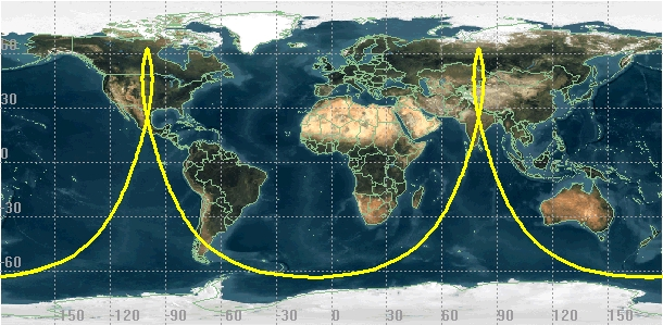
Highly elliptical orbits can pass directly over the equator at 0° (or 180°), or over the poles at 90°. Based on this, HEO can be equatorial or polar. Tundra Molniya’s orbits are both HEO examples.
Pros:
- almost two times more affordable satellite placement compared to GSO;
- wide coverage;
- wide use of various frequency ranges without registration (unlike GSO, with practically no free space or free frequencies left).
Cons:
- to ensure round-the-clock continuous broadcasting, the number of spacecraft increases to seven;
- the satellite antenna must be mobile, and the transmitter power should be higher due to the large apogee;
- the long signal propagation time makes HEO satellites unsuitable for real-time applications.
Scope of HEO satellite orbits explained: communication, satellite radio, Earth Observation.
Burial orbit
The satellites are transferred to the burial orbit after they have served their time. How long does a satellite stay in orbit will depend on its purpose and placement. There are two main satellite “dumps”:
- for GSO satellites. Located 200 km above GSO.
- for military satellites with nuclear installations, the so-called nuclear graveyard orbit. Extends at an altitude of 650 to 1000 km.
All other spent satellites either fall to the ground, partially or completely burning up in the upper atmosphere, or turn into drifting space debris. The space debris problem is growing ever more acute. We should start working on the solution for satellite orbit correction and debris removal now; otherwise, tomorrow, the near-Earth traffic in satellites orbits may be closed forever, and we will have to forget about leaving the district for large space routes.


Thank you for your comment! It will be visible on the site after moderation.