Meteosat Third Generation Imager-1 Pushes Weather Forecasting Forward in Europe
8th May 2023
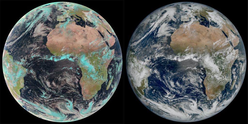
On 4th May the ESA released the very first image from the new generation of weather forecasting satellites. ESA developed the latest meteosat project in cinjunction with the European Organisation for the Exploitation of Meteorological Satellites (EUMETSAT).
Meteosat Third Generation Imager-1 was launched on an Ariane 5 rocket towards the end of 2022 and this stunning image, captured by technology called the Flexible Image Combiner, shows much of Europe and Africa, with clouds covering a huge amount of the European continent.
How the Meteosat MTG I-1 Changes the Game
We can see that the image is impressive, of course, but what does it do differently when compared to predecessors? Well, the instruments carried onboard this satellite provide higher resolution and are able to capture images more frequently when compared to the previous second-generation satellites.
Simonetta Cheli, the Director of Earth Observation Programmes at the ESA, explained in more detail:
This image is a great example of what European cooperation in space can achieve. The level of detail MTG-I1’s image reveals, unachievable over Europe and Africa from a geostationary orbit until now, will give us a greater understanding of our planet and the weather systems that shape it.
This image represents not just what can be achieved through European expertise but our determination to ensure the benefits of new technology are felt by communities in Europe and beyond.
Specific details include the snow coverage of the Alps mountain range and even cloud vortices that can be seen over the Canary Islands off the coast of Africa. These are factors that can be very helpful for weather forecasting, but would not have been captured in the previous generation of instruments.
The image is also able to provide more information about high-latitude clouds. This means that forecasters will be able to more easily monitor severe weather conditions in these regions.
Filling in gaps
As you would expect, the images were seen as a great breakthrough for the World Meteorological Organization, with their Head of the World Meteorological Organization Space Systems and Utilization Division, Natalia Donoho, explaining more of the benefits:
“The high-resolution and frequent repeat cycle of the Flexible Combined Imager will greatly help the World Meteorological Organization community to improve forecasts of severe weather, long-term climate monitoring, marine applications, agricultural meteorology, and will make an important contribution to the Early Warnings For All Initiative, in particular on the African continent.”
A full constellation of Meteosat MTG satellites is due to be in orbit by 2026, providing even more coverage and data. The satellites are something of a triumph for collaboration too, and while the development has been led by Thales Alenia Space, the Lightning Imager was created by Leonardo in Italy, while Telespazio provides thelaunch and in-orbit services.


Thank you for your comment! It will be visible on the site after moderation.