How Ukraine Gained an SAR Satellite: Crowd Funding in Time of War
17th Oct 2022
Ukraine’s defense in the face of Europe’s largest military invasion since World War II has been likened to the 20th Century’s land wars with artillery duels and combined arms attacks. However, there is a distinctly 21st Century edge to the country’s military efforts. One of the most important new-era components is satellite imagery. And in this regard, Ukraine utilising such imagery to defend itself against one of the planet’s pioneering space powers points to something interesting. Let’s explore it.
The people’s satellite
In August 2022, a Ukrainian project to crowdsource funds for Turkish ‘Bayraktar’ UAVs met with an unexpected windfall. Instead of selling the three drones desired, the manufacturer donated them to the Armed Forces of Ukraine. This left the organizers, namely the Prytula Foundation, with over GBP 12.5 million (USD 15 million, as of mid-August) in the bank. The Prytula Foundation told Orbital Today that they sat with the Ministry of Defense and asked where to best utilise the funds.
“Minister of Defense Oleksiy Reznikov had several options,” a foundation representative told OT. “But after a while, he asked if we could go for the option of a satellite. We thought that was just a good option to buy what the MoD really needs and will see a great improvement with.”
“For us, though, this is not just a story about a satellite, there is also an extra factor of responsibility. We are responsible for every coin of donations either from big companies or from children who collect money by singing in the park, selling handmade jewellery, homemade pastry or grandmothers who bring their last money to us in handkerchiefs. So we are happy that all these donations were used for something huge and really effective for Ukrainian Armed Forces.”
What were they looking for?
Ukraine already had access to satellite imagery when Reznikov made his suggestion. Much of the imagery came from satellites sporting Electro-Optical (EO) devices. What the Ukrainians needed would come from Synthetic Aperature Radar (SAR) satellites. What is the difference?
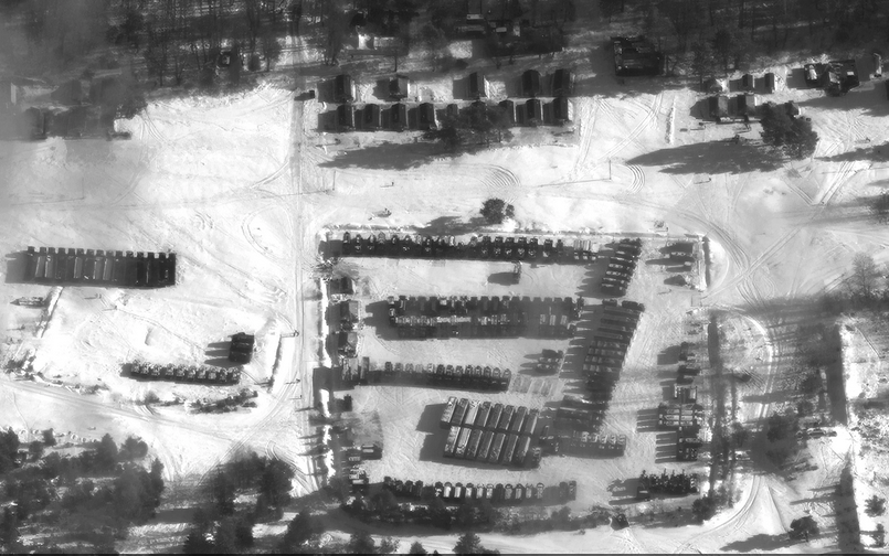
Satellites carrying EO equipment have imaging devices that would be familiar to anyone. They consist of a very high resolution telephoto lense and a sensor. Commercially available EO satellites such as Airbus Pleiades Neo offer images with 30-cm resolution. However, these satellites need light and a lack of cloud cover – and a lack of vegetation. Trees offer some cover for equipment and people from such satellites.
SAR satellites remove these strictures. By utilizing an imaging radar system, the satellite processes the return signal to create an image. Light is not required, and cloud cover is not an issue. At the wavelengths that SAR uses, plant cover such as trees also becomes ineffective.
As opposed to radar systems designed to detect objects such as aircraft, where the presence of a return signal is the important factor, with imaging radar, the intensity of the return signal is vital. This is because there would almost always be some echo for SAR radars pointed at the ground, but it changes with the material that is reflecting the signal. The variation is telling.
The Synthetic Aperture in SAR comes from the method used to take advantage of the movement of a body to increase the apparent size of the radar, and in doing so, increase its resolution. For Earthbound systems looking at the sky, it’s easier (but still a feat!) to use multiple stations across the globe, as the Very Long Baseline Array radio telescope does. In space, and looking Earthward, the movement of a single radar imaging satellite, which transmits a signal from one point in its orbit, and picks up the return signal at another, is a commercially more feasible approach to creating the equivalent of a larger dish.
For Ukraine, with its many forests providing a roof in Summer and frequently cloudy skies in Winter preventing EO-derived observation, SAR observation became vital.
Satellite imagery and the run-up
As Russia prepared for the broad-scale invasion of Ukraine, satellite imagery played a vital part in convincing the Ukrainian government and the world that an attack was going to happen. Starting in December 2021, the U.S. started releasing satellite imagery of the build up of Russian troops along Russia’s border. EO imagery was often sufficient for this, as armoured vehicle parks and the tracks to them were easily visible in the snow. Growing numbers were easily seen, as were the types of units, including some that had not been seen during troop exercises in the same area in years past.
The imagery shared publicly was mostly EO originated at first, though SAR imagery also appeared in the media. Not enough of the imagery was SAR sourced, though, and EOS Data Analytics, owned by Ukraine-born Max Polyakov, appealed to Earth observation companies world-wide to share current EO and SAR images with the Ukrainian government. EOS Data Analytics had its own EO satellite, but its SAR project is not expected to take to orbit until 2024.
Even the U.S. Government struggled to adequately supply such material at first. For example, the National Geospatial-intelligence Agency (NGA) pointed to the changes they needed to make to provide Ukraine with imagery. In particular, the NGA pointed to its relative lack of experience in dealing with SAR imagery from commercial providers. NGA director Sandra Auchter, speaking at the annual GEOINT Symposium in Colorado in April 2022 stated that,
“As far as I know, we’ve been able to provide commercial imagery for the Ukrainians use within minutes of collection. And for someone who has been in the business for as long as I’ve been in and seeing that evolution of how we can collect this imagery and how we’re able to use it, for us to be able to provide that to a foreign partner in such a short period of time is incredible.”
Source: Via Satellite
Commercial providers such as ICEYE were a criticial, and motivated, component of the supply of satellite data at this time. As ICEYE wrote to Orbital Today,
“Ever since the aggressive military action from the Russian government against Ukraine began, ICEYE has cooperated with the relevant governmental authorities in Finland, Poland, the European Union, the UK and the United States, to provide assistance in their respective responses to the war.”
The Ukrainian government was soaking up as much imagery as it could. At GEOINT, Director Auchter remarked that the Ukrainian government had “used or streamed or downloaded more than 40 million square kilometers of area” in the first two weeks of the conflict.
Whose hands?
Whether all of this material was being used by the Ukrainian military only was a question. That point was emphasized in a Washington Post series on the run-up to Russia’s widening of the war. There was a reluctance to share some imagery before 24th February, as “Ukraine’s own intelligence apparatus was also shot through with Russian moles…”
Unfortunately, the assessment is correct. In July 2022, Ukrainian president Volodymyr Zelensky sacked his childhood friend Ivan Bakanov as head of the Security Service of Ukraine (SBU) after several high profile spying cases among the latter’s subordinates arose. Moreover, the intelligence agencies are not alone in suffering from this known malaise. A top manager of one of the Ukrainian Space Agency structures, Viacheslav Onysko, was arrested in September 2022 for spying for the Russians.
Removing the Department of Redundancy Department
Along with the issue of spying, there is the issue of Ukraine’s bureaucracy and what can be done versus what should be done. Just as vestiges of the Kremlin-oriented human apparatus are removed, there is still a lot that needs to be done to ease the bureaucratic strictures set in place over the Soviet and immediate post-Soviet eras.
The exigencies of war made for some streamlining that removed layers of bureaucracy, and with it, possibilities for misuse, when it came to obtaining and utilising the imagery.
“We can’t disclose a lot of details, as it deals with the intelligence of our country during war,” the Prytula Foundation told OT. “The idea of the need for a satellite came from the Ministry of Defense and we were in touch with its officials to fix all the documents and ensure they have all rights for the satellite.
All the process was under supervision of the MoD. We had some issues to fix with the whole bureaucracy process, because it is a unique case when a charity buys a satellite from a private company with crowdfunded money. Such purchases normally take years, but we had to do it in a short time, literally in a month, and we managed to do this. Now everything is set and working for the victory of Ukraine. “
Obtaining the satellite
How the red tape and black hats were cut through will make for heavy reading after the war. But the broad outlines of how a crowd-funded SAR imagery satellite fell into the hands of the Ukrainian government are known.
In summer 2022, a series of crowd funding campaigns to purchase Bayraktar UAVs for the Armed Forces of Ukraine were held. For example, the people of Lithuania garnered nearly EUR 6 million in a matter of days to purchase one of the armed drones, including weapons. On 2nd June, the Turkish manufacturer, Baykar, announced that it would donate the UAV and let the Lithuanians donate the funds to other causes to help Ukraine.
Grateful yet not to be outdone, the Prytula Foundation organised a drive to crowd fund USD 15 million for three Bayraktars. The public outpouring garnered USD 10 million in 24 hours, and the rest came within days. Once again, Baykar offered the drones for free, and the foundation met with Minister Reznikov.
Bringing everyone together
Once the idea to acquire a SAR imagery satellite was broached, the foundation turned to Max Polyakov for expertise. The organisation already knew him due to their shared interest in helping Ukraine.
Serhiy Prytula told OT that, “Our contact with Max Polyakov started when I got to know that he became a big donor of our Foundation in March 2022. He started sending huge donations which we have been turning into significant help for our Army. We were able to buy a lot of expensive equipment for the Army with these donations like unmanned aerial vehicles, night vision goggles and so on. This is how we met and started good online communication with him.
When it came to the idea of buying a satellite at the request of the Ministry of Defense, we knew there was good expertise that Max could offer. He and his team are the only people who launch space rockets and have a great experience in satellite imagery analysis. Max Polyakov is the Ukrainian guru of space technologies, so he was our instant choice to ask for quality expertise in this field. And his experience and knowledge came in handy with our satellite case.”
With Polyakov and EOS Data providing expertise, the foundation held a competitive tender to acquire the output of a SAR imaging satellite. The tender was a bit vague on details, though. “Keeping it all secret was also one of the important things to ensure the success of the purchase,” Prytula noted.
ICEYE wrote that, “after careful deliberation internally and in consultation with government agencies, we have chosen to respond to this request by providing space-based capabilities to the Ukrainian Government. We have strongly condemned this invasion perpetrated by the Russian government. We firmly believe SAR technology and its capabilities will add significant value to the Government of Ukraine, now enabled by the work of the Serhiy Prytula Charity Foundation.”
In practice
While the tender was done quietly, the conclusion of the deal was well advertised. Ukrainian donors received confirmation that the funds had been well used. The Prytula Foundation noted that on 29th September, Minister of Defense Reznikov announced that, “at least 60 russian military vehicles of different types were destroyed in only two days of the satellite’s active use.”
In another bureaucracy-bypassing maneuver, the imagery obtained goes directly to the Ministry of Defense.
What’s next?
The immediate use of SAR imagery by the Ukrainian army has been an important component of its autumn 2022 campaign. ICEYE points out that the technology behind SAR has been available for decades. “Since then,” ICEYE notes, “satellites, especially SAR satellites, have seen incredible improvements with their technology – they are much more advanced, they are much smaller, they work much faster, and have new capabilities that weren’t available before.”
While it is not discussed much, there are other kinds of data that can be used in conjunction with SAR to pinpoint locations of interest. For example, military analysts have pointed to Russian military convoys deploying local GPS signal interference measures in hopes of confusing precision munitions from the Ukrainian side. Detecting such distortions combined with SAR images may be the workaround needed to counter the subterfuge. With winter coming, heat traces and the lack of cover may offer opportunities for other types of imaging.
Crowd funding the military’s needs can be traced back in the United States back to 1812. Cities and organisations raising funds to buy WWII fighter aircraft is better known these days. But the Ukrainian effort probably marks the first use in warfare of imagery from a publicly funded satellite.


Thank you for your comment! It will be visible on the site after moderation.