New Report Shows Satellite Applications for Humanitarian Emergencies
31st Aug 2022
Satellites. Few things have such a huge impact on your life without you even thinking about them on a day to day basis. The truth is that the roles that satellites play have only been partially discovered and considered. Satellite applications for humanitarian emergencies is one such field that is already developing.
In a pilot programme called The UK Humanitarian Innovation Hub, scientists have been looking at more ways that we can use satellites for humanitarian emergencies, including environmental, economical, and societal issues. Most of the potential help comes from gathering data and potentially analysing patterns, as well as better understanding the world around us.
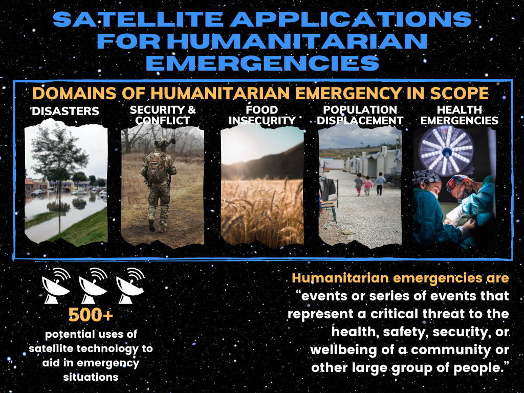
You can read the report in full here, as the think tank has explored over 500 potential uses of satellite technology to aid in emergency situations.
The Role Satellites Already Play
We’ve seen satellites play a huge role already in certain parts of the world. iMMAP is an example, a charitable organisation that has used both AI and satellite technology to help migrants to find suitable sites for new settlements. Almost 2 million refugees have entered Venezuela. The government there placed many of them in areas that are not viable for development. The resulting settlements lack water and proper sanitation, and have no access to the materials and utilities needed.
iMMAP’s technology helps to map new settlements for those who have migrated to the country, as well as providing early warnings of cross-border conflicts.
Amnesty International has also used satellite technology to map crimes against the Rohingya people in Myanmar, showing the areas where people have been targeted and subjected to numerous atrocities. Mapping Crimes Against Rohingya is an area of the website that is available for anyone to see, and the data is free to use.
There are some clear, even obvious uses of how satellites can help with current humanitarian crises. Many of the current humanitarian efforts to get aid and supplies to Ukraine are able to make use of satellite data for information on where the infrastructure is damaged, where help is most desperately required, and humanitarian routes out of the war torn cities. There are plenty of aid operations that do not have this kind of information readily available, and further satellite support is needed.
Future Uses For Satellite Technology
In Beyond Borders: Satellite Applications for Humanitarian Emergencies, the authors noted many potential applications. This including some more abstract potential methods for helping in humanitarian disasters.
We won’t go through the whole 500+ ideas, but some of the potential methods show how space technology can improve the world we live in, and the aid we can potentially provide. Some methods are already in use, others require further technological advancements, or greater hardware availability, to be viable options.
Disasters
When a disaster occurs, including war, or a natural disaster, SatComms systems can be one of the ultimate tools.
In many instances, satellites are crucial for evaluating the initial damage that is caused. For instance, via flooding or warfare. They may even play a role way before that, as early warning systems can assist with evacuation and getting people who are at risk out of danger.
The mapping of natural resources, made possible with satellite imagery, is another way that governments and charities can be better prepared when it comes to understanding famine and potential shortages.
Subsidence, erosion, and the financing and insurance of property and buildings may also be better evaluated using these images, with more accurate and far-reaching data available through satellites.
Conflict
Of course, satellites will be used in warfare, and sadly warfare is not on the brink of disappearing from humankind. Outside of military forces, there are plenty of humanitarian organisations who may need satellite information to respond to conflict, and the fallout from conflict.
Some examples of this include the monitoring of prison camps, and of the refugee fallout and people leaving war-affected areas. Search and rescue missions can benefit from the use of mapping and imagery, in attempts to save citizens.
The assessment of damage, and the impact that war has on natural resources as well as infrastructure exposure are also made a lot easier by satellite tech, allowing further planning for aid and evaluation of how countries can rebuild.
Satellites also allow us to keep more accurate records of warfare and violence, and the damage done to human populations and to infrastructure, and even monitor for the compliance with peace treaties that may be in place among certain countries and their militaries.
Measuring Food Insecurity
Measuring, and mitigating against food insecurity is another excellent use of satellite technology, as imagery has evolved to the point where more and more information can be gathered. As the report outlines, “spectral information in satellite imagery can unlock important dimensions like crop health, crop-type mapping, soil moisture, suitability maps, and many other food security–related indicators that support more complex crop performance models, pest and disease models, food demand, and more.”
With changing climates around the world and famine still causing a huge problem in many less-developed countries, crop data and food insecurity data is crucial, and could save lives.
Health Emergencies
Health emergencies are certainly topical, and the satellite data that is available can play a part.
As well as planning and control for immunisation and even contact tracing, mapping the potential spread of disease and illnesses. Though satellites may not be able to map the specific threat from diseases originating, potential breeding grounds for disease and illness such as stagnant water can be analysed.
The Future of Satellite Applications for Humanitarian Emergencies
From weather forecasting, to television, to GPS…Satellites have changed the way we all live, all within the space of one lifetime. If we were to fast-forward 50 or 100 years in the future, satellite technology will doubtless be very different, and its applications will have grown. Finding ways in which we can save lives, and improve lives, must be a focus for the near future, as pandemics and war still plague the world.


Thank you for your comment! It will be visible on the site after moderation.